A product in one week

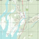
BlueToque Software has been working on TrueNorth Geospatial, our light geographic information system, for a few years and we began getting feedback from our users that even though TrueNorth is easy to use (much easier than an enterprise GIS), they needed something even simpler. One of our users in particular needed a tablet based application […]

Continue reading

TrueNorth Geospatial released

Blue Toque Software is very happy to announce that TrueNorth Geospatial has been released. This project has occupied our small company for the past five years. TrueNorth was designed and built to give people a simple “word processor” style interface to a Geographic Information System (GIS). Built on standards-based APIs, and supporting hundreds of file formats and devices, we hope that TrueNorth will fill the […]

Continue reading

SARScene 2013

We will be exhibiting at SARScene 2013 at the Pacific Region Training Centre (PTRC) in Chilliwack BC this Saturday October 19th at the trade show. Company Principal Michael Coyle will be speaking at the conference as well on various topics from Unmanned Aerial Vehicles, Social Media and SAR, and Integrating Technology with Search and Rescue. […]

Continue reading

TrueNorth in beta testing

Sometimes you work on something so hard for so long you actually miss the point where it became, for lack of a better word, “usable”. There’s this idea in software development of the minimum viable product, which in my opinion isn’t the same thing as the minimum useful feature set, but there’s probably some debate. The first […]

Continue reading

Implementing ArcGis tile layer using BruTile

I recently went to the trouble of figuring out how to use BruTile to access ArcGIS online maps. ArcGIS serves the maps as a tileserver. I came up with the following URL to access the tiles of the world topographic map. http://services.arcgisonline.com/ArcGIS/rest/services/World_Topo_Map/MapServer Then I used the following code to configure the TileSource TileSource = new ArcGisTileSource(m_url, […]

Continue reading

Announcing SharpGpx

One of the major features of TrueNorth is data interoperability, and one of the most common file formats for exchanging GPS data is GPX. GPX is supported by many smart phones, GPS devices, and hundreds of software packages. So, one of the earliest features added to TrueNorth was GPX support. GPX is an XML File […]

Continue reading